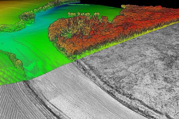
urbanists.social is one of the many independent Mastodon servers you can use to participate in the fediverse.
We're a server for people who like bikes, transit, and walkable cities. Let's get to know each other!

Server stats:

537
active users

#lidar

6 posts6 participants0 posts today

#Indien führt in #Delhi einen umfassenden #Baumzensus durch, um #Wälder besser zu schützen und den Kampf gegen #Klimawandel und #Wüstenbildung zu stärken.

Freiwillige und Experten erfassen #Baumarten, Zustand und #Kohlenstoffspeicherung.
Moderne Technologien wie #LiDAR und #Drohnen sollen die Zählung unterstützen.

Ziel ist es, durch mehr #Bäume die #Klimaneutralität bis 2070 zu erreichen und die #Luftqualität zu verbessern.

dw.com/de/warum-z%C3%A4hlt-ind

Indien | Abholzung Hasdeo Aranya in Chhattisgarh
Deutsche Welle · Warum zählt Indien seine Bäume?By Sonam Mishra
Replied in thread

@TheOneSwit @guenther @fenstersims @bmdv @HLunke

Genau: #Toleranz bezieht sich nicht darauf, daß der Staat es tolerierte, wenn eine absolut gesetzte HÖCHSTgeschwindigkeit überschritten wird, sondern auf die #Messtoleranz.

Jede #Messtechnik hat eine gewisse Ungenauigkeit und die darf in einem #Rechtsstaat nicht zum #Bussgeld führen. Moderne Geschwindigkeitsmessung (z.B. #Lidar, #SectionControl) ist bei korrektem Gebrauch viel genauer als der pauschale Toleranzabzug (aus den 1970ern?) vorgibt.

Ein autonomer #Roboter der Osaka Metropolitan University navigiert mit #Lidar präzise durch #Hochbeete und kann sogar empfindliche Früchte wie #Erdbeeren ernten.

Grundlage ist eine Kombination aus virtueller Simulation und realer Testumgebung. Das System spart Zeit und Kosten und eröffnet neue Möglichkeiten für automatisierte #Landwirtschaft.

Voraussetzung sind aber kontrollierte Umgebungen, Fahrbahnen und etwa Hochbeete. 😁

golem.de/news/erdbeerernte-aut

Golem.de · Erdbeerernte: Autonomer Roboter navigiert mit Lidar im Hochbeet - Golem.deBy Mario Petzold

A decade ago I presented this pair of slides to an all-staff seminar at the Australian Antarctic Division. First shows a lidar pass as a reasonable scale for piloted aircraft. Second is a dense point cloud of a ship in sea ice showing a reasonable scale for RPAS/drone operations.

This is still true. At the time no small RPA existed that could operate in those conditions. In 2021/22 I was flying one in the Arctic, and it turns out slide 2 was very optimistic!

RiverREM - Generating River Relative Elevation Model (REM) Visualisations
--
github.com/OpenTopography/Rive <-- shared GitHub repository
--
opentopography.github.io/River <-- shared documentation
--
opentopography.org/blog/new-pa <-- shared Open Topography blog post about RiverREM
--
H/T Heidi Luchsinger / Open Topography
[this post should not be considered as an endorsement of this product aka caveat emptor]
#GIS #spatial #mapping #remotesensing #earthobservation #Python #LiDAR #RiverREM #visualisation #hydrology #water #river #rivervalley #floodplain #terraces #GitHub #opensource #opendata #DEM #REM #model #modeling #RiverRelativeModel #documentation #tutorial #learning #tool #elevation #raster #sinuosity #drainage

Fairly disappointed, but not altogether surprised, that the new Non-forest Tree mapping from Forest Research is not really useful for mapping trees on #OpenStreetMap. Mostly it only has 1 m resolution Lidar, so the map shows canopy above 3 metres in height. Undoubtedly useful for other purposes, such as shade calculations.

forestresearch.gov.uk/tools-an

#TreeMapping #Lidar #EnvironmentAgeny # ForestResearch #OpenData

Forest ResearchTrees Outside Woodland Map - Forest ResearchThe Trees Outside Woodland (TOW) map is a project to map trees in England above 3 metres and 5m2 area outside of woodland, including small woods, groups of trees and lone trees.

Urban settlements in the #Amazon region? They existed long before Columbus. But knowledge about them was more or less lost for a long time. In her keynote lecture on Tuesday, Bolivian archaeologist Carla Jaimes Betancourt from the #UniBonn explained why #Lidar technology is now bringing back this knowledge and what new discoveries have already been made.
In an interview, she also told us why she became an archaeologist 👇
#KielScales25 #Urbanism #Bolivia #Archaeology #LlanosdeMoxos #landscapeengineering #landscapearchaeology #keynote